

It’s hard to tell who said it first, but the quote “Happiness is listening to a waterfall” may well have originated in the Shenandoah Valley. Shenandoah National Park alone has more than a dozen named waterfalls and dozens more course through Virginia’s Blue Ridge Mountains. Here we list a few of the most accessible.
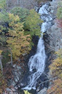
Dark Hollow Falls
One of the most popular waterfall hikes in the Valley, not only because of its singular beauty but its ease of access. The trailhead and parking lot are right on Skyline Drive between mileposts 50 and 51. It’s all downhill till you get to the bottom of the 70-foot falls, and it’s quite steep on the return, but the whole hike is just 1.4 miles round trip. Perfect for family outings, and after the hike stop in at the Byrd Visitor Center, about a quarter mile south on the Drive.
Whiteoak Falls
 Actually a series of six falls, Whiteoak Falls offers a direct, easily followed trail to a magnificent overlook of the first major cascade, about 86 feet high. (The trail does continue from that point, and other falls may be seen.) This hike to that first overlook is about four and a half miles round trip, crossing a number of wet spots after rains, and rocky in some areas. The trailhead and parking lot are located between mileposts 42 and 43 on Skyline Drive. The entire canyon is a popular hiking spot and quite a few other trails may be explored nearby. The scent of ancient hemlocks surrounds you every step.
South River Falls
Your starting point is the South River Picnic Grounds, between mileposts 62 and 63 on Skyline Drive. With a drop of 83 feet, South River is the third-highest falls in Shenandoah National Park. There are several routes to choose from but the 2.6 mile round trip from the picnic area to an observation point is probably the most-used. Roughly parallel to that trail is the South River Fire Road, which can be used to map out a bit longer circuit hike.
Apple Orchard Falls
Start at milepost 78.4 (Sunset Fields Overlook) on the Blue Ridge Parkway, just north of Peaks of Otter. You can take the direct, 1.4 mile trail down to the falls or start from Forest Road 59 and connect with Cornelius Creek Trail for a 5.6 mile circuit. To get to the FR 59 trailhead, take exit 168 off I-81 just north of Buchanan, follow Route 614 through Arcadia, then turn left at the North Creek Campground sign onto FR 59. In about 4 miles, past the campground, the road will end at a trailhead. The Apple Orchard Falls Trail leads left out of here; the Cornelius Creek Trail is to the right. The trail is steep and rocky but the 200-foot falls are more than worth the effort.
Falling Spring Falls
A near-vertical 80-foot waterfall visible from the overlook on Route 220, about five miles north of Covington, in Alleghany County. References to the attraction appear in Thomas Jefferson’s “Notes on Virginia.” While there are no maintained trails, the property has been renovated and a picnic area added, so that visitors can more safely stop and enjoy the view.
Fallingwater Cascades
Spend the night at Peaks of Otter Lodge, then take the Blue Ridge Parkway north about two and a half miles to the parking lot on the left. The trailhead is at the west side of the parking lot—note the sign for “Fallingwater – Flat Top National Recreation Trail.” Turn right at the sign and immediately start descending. The trip is about one and three-quarter miles, and not terribly strenuous–another good option for family forays.
Waterfall Hike Safety
Use common sense. Don’t forget the simple fact that wet rocks are slippery, don’t venture too close to an edge, don’t ignore warning signs, and don’t get so caught up in taking a selfie you take a fall instead. Beyond that, while all the trails listed above are well-marked, some, particularly in Shenandoah National Park, crisscross a network of other trails and it’s not impossible to take a wrong turn. Map it out first, and plan your hike to get back to your starting point well before dark. And realize that cell phones or a GPS may not always function deep in a forested canyon.
Banner photo at top: Dark Hollow Falls, Shenandoah National Park, courtesy National Park Service.