

If the glimpse of a dirt path fading into the woods excites you, if scenic vistas of the Blue Ridge or the solitude of a silent wilderness lift your heart, then we hope you visit the Shenandoah Valley on June 3rd, 2017 –National Trails Day—to explore some of the Valley’s unforgettable hiking trails. And even if you miss that day, the trails are still there.
While a list of “must-do” hikes in the Shenandoah Valley might draw agreement from as much as one percent of outdoor enthusiasts, we believe the following six ought to at least be high on anyone’s hiking priorities.
Starting from the north end of the Valley:
Devil’s Nose Trail
“In the Martinsburg, West Virginia area, we are blessed with some great hiking opportunities,” said Mark Jordan, Executive Director, Martinsburg/Berkeley County WV Convention and Visitors Bureau.
“Of our local trails,” Jordan commented, “my favorite is the Devil Nose trail, which has a wonderful overlook and allows hikers to venture through various natural habitats of mountain laurel, rhododendron and hemlock groves….plus it’s a fairly quick and easy hike.” (Devil Nose is in Sleepy Creek Wildlife Management Area, a popular hunting spot, so wearing blaze orange during any hunting season is suggested.) This hike takes you down rugged trails to a stream with numerous rapids, rock formations, a waterfall, and ten-foot high blooming rhododendrons in spring. Plan on 1 to 1 ½ hours round trip. Devil’s Nose parking area is about 30 minutes from Martinsburg. Take Rt. 9 West through Hedgesville, turn left on Mountain Lake Road, then turn right onto Audubon Road through the Sleepy Hollow subdivision. Turn right onto Maverick road, and follow it until you see the parking area. Find out more at the Martinsburg/Berkeley County WV Convention and Visitors Bureau.
Old Rag Mountain
The parking lot on Route 600 near Nethers holds 200 cars, but you’d be amazed how early it fills up. If you’re looking for solitude, plan your hike for a weekday. This is one of the most popular trails on the East Coast; the 9.2 mile circuit is rated “very strenuous” by Shenandoah National Park officials. Parts of the trail involve a true rock scramble that is not for the weak of heart. But views are spectacular at any time of year, especially from the 3,291-foot summit. If you could only do one hike in the Valley, Old Rag would be a good candidate. Stone pillars help you find your way on many of the park’s trails, but mapping out your route ahead of time is advised. (Deep in forested canyons, GPS may not always work.) Visit here for maps of Old Rag and many other great hikes in the park.
Hawksbill Mountain
An “easy” two-mile up and back hike that takes you to the highest peak in Shenandoah National Park, at 4,049 feet. Nearly 360-degree views of the Valley from an observation platform are incomparable. Start at the Upper Hawksbill trailhead, on the west side of Skyline Drive at milepost 46.7, or consult park maps for other routes. Lucky hikers may get a glimpse of the once-endangered peregrine falcon, whose numbers are increasing due to restoration projects in various parts of Virginia, including Hawksbill Mountain. The current fee to enter Shenandoah National Park is $25 for a single vehicle, or you can get an annual individual pass for $50. There are dozens of other hikes in the park that could make any “must-do”list.
Humpback Rocks
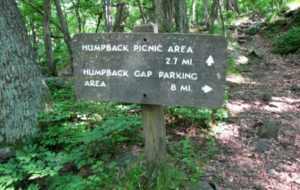 Starting from nearby Waynesboro, take the Blue Ridge Parkway to the Humpback Rocks Visitor Center (540) 943-4716) at MP 5.8. You will find both beauty and history here. The rocks served as landmark for wagon drivers hauling goods along the old Howardsville Turnpike, an important route across the Blue Ridge until the railroads got there. A farm museum next to the Visitor Center illustrates the life of the 19th Century agrarians. There are actually several trails, and getting to the rocks requires a short, but significantly steep climb. A one-way hike to the Humpback Rocks picnic area is 3.9 miles, starting from the parking area at MP 6 on the BRP, and there are shorter routes to consider. If you want a 360-degree view, this is a good one—the Blue Ridge, the Alleghenies, the Shenandoah Valley and the Piedmont to the east are all clearly visible.
Three mountaintops near Bedford are collectively known as Peaks of Otter—Flat Top is 4.4 miles one way to the 4,004-foot summit. Sharp Top (1.5 miles to the 3,862-foot summit) is probably the most popular of the three, but is steep and not easy. Harkening Hill is 3.3 miles to the top, at 3,375 feet, and goes by an enormous boulder balanced on a small rock. All offer splendid views. Get more information at the Peaks of Otter Visitor Center, MP 85.9 on the Blue Ridge Parkway. Make Peaks of Otter Lodge your home base for hiking these trails.
McAfee Knob and the Appalachian Trail
Commonly referred to as “the most photographed spot on the AT,” McAfee Knob is “moderate” hike of 8.3 miles, round trip, with stunning views from the 3,197-foot summit and a precarious-looking rock outcrop that does indeed make a great photo op. (See our banner photo at the top of this page.) This a landmark hike but be aware—it’s crowded on weekends and parking is limited. To get there: From I-81, take Exit 141 to VA 419/311. Go north about 1/4 mile and turn right on Route 311. Go 5.5 miles north on Route 311 to the top of Catawba Mountain, where there’s a gravel parking lot and an AT crossing. From the parking lot, walk back across Route 311 to begin the hike.
It’s worth mentioning that 554 miles of the Appalachian Trail traverse Virginia—more than any other state. About 104 miles of it go through Shenandoah National Park, and that whole section is considered good for entry-level AT explorers. You’re never too far from Skyline Drive, and the hills are quite manageable.
Want more options, or help planning a hike? Click on “Contact Us” at the bottom of the page and we’ll find you an expert for the region you plan to visit.
Banner photo of McCaffee Knob courtesy Virginia Tourism Corporation